San Guillermo Mountain is a peak in the Los Padres National Forest, in the Lockwood Valley area. The peak is at my limits for a day drive (about 90 minutes each way). The Web site https://www.scadacore.com/tools/rf-path/rf-line-of-sight/ gives it an almost clear line-of-sight to downtown Los Angeles. This means I may be able to activate it on 2 meters and still get the required 4 contacts.
I didn’t quite make it. AllTrails describes the route as a loop:
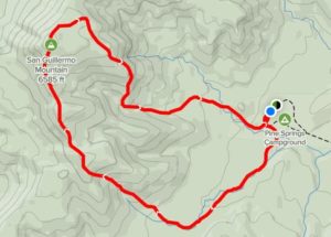
I took what appeared to be the shorter side of the loop (the downhill part), to make it into an up-and-back. How hard can 1.4 miles be?
There is really no trail, just rummaging through scrub. I was following the path on my cell phone. After almost 2 hours I had gone only 1.2 miles. I turned around and headed back. I had a late start and did not want to be out there in the dark.
After coming back to the parking lot, I tried the other end of the loop. It did have a decent visible trail and was quick going. I will try this route next time.
Other notes:
- My Subaru’s GPS calls Forest Rte 7N03/Grade Valley Rd by the name Mutau Flat Road. Google maps has its as Forest Rte 7N03/Grade Valley Rd which is what Alltrails provides.
- Pavement ends at 1.4 miles on this route. The following dirt road is very uneven.
- Turn right at Pine Springs Road to get to the campground. No signs posted about reservations required, fees required for day use, etc. Since none of the camp sites were used, I pulled into one for the day.
- None of the two trails are marked. The more visible trail starts at camping slot 8.